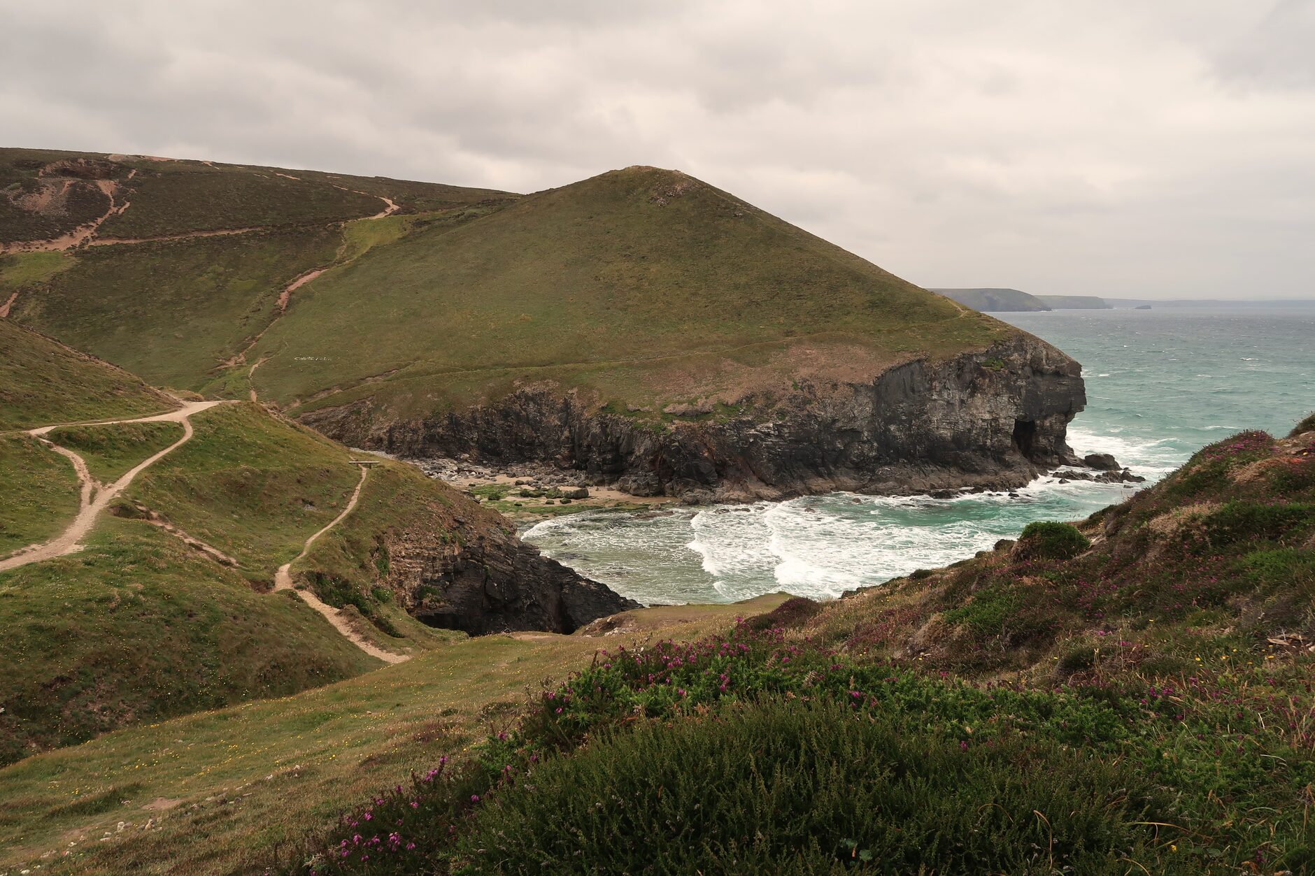
The South West Coast Path is Britain’s longest National Trail, 630 miles from Minehead in Somerset around to Poole in Dorset. The Cornish section is the longest single stretch of it: more than 300 miles of coastline from Marsland Mouth in the north, where the Devon border cuts across a stream, to Cremyll on the Tamar in the far south east. Walking it — in an afternoon, in a week, or end to end — is one of the great long-distance walking experiences in Europe, and comfortably the best way to see the county’s coast.
This section-by-section guide to the Cornish coast path covers every stretch, the difficulty of each, the highlights, the sensible overnight hubs, and the practical detail you need to plan a day out or a multi-day trip. One day, one week, or a full end-to-end walk: the aim here is to help you make sense of a path that is genuinely enormous, and to walk the right bit of it for the time and legs you have.
The South West Coast Path in Numbers
- Total length: 630 miles (1,014 km).
- Cornish section: approximately 300 miles.
- Total ascent of the full path: around 35,000 m — more than four times the height of Everest.
- Time to walk Cornwall fully: 25–35 days for an average walker.
- Best months: late April to early October.
- Recommended map series: OS Explorer 102, 103, 104, 105, 106, 107.
How the Cornish Coast Path Is Structured
The official guide divides the whole trail into 52 sections, each roughly a day’s walk. The Cornwall portion runs from about section 17 (Marsland Mouth) to section 41 (Cremyll). For anyone planning a trip rather than filing a spreadsheet, it is easier to think of the Cornish coast in larger regional chunks, each with its own character, difficulty and feel.
1. North Cornwall: Marsland Mouth to Boscastle (35 miles)
Wild, dramatic, and the toughest part of the entire trail. Hartland Quay’s contorted slate-fold cliffs, the beaches around Bude, Crackington Haven under its high cliff, Boscastle’s slot of a harbour. The pattern here is relentless: a plunge to a stream, a steep haul back up, repeated all day. Not a first choice for anyone new to hill walking without some preparation.
2. Boscastle to Padstow (40 miles)
Tintagel Castle on its half-island, Bossiney and Benoath Coves, the slate ledges of Trebarwith Strand, Port Isaac, the great headland of Pentire Point, Polzeath, then the Camel Estuary leading into Padstow. Dramatic still, but a shade more forgiving than the Devon-border section. If you want to understand why people fall for this town, the wider Padstow guide covers where to eat and stay at the finish.
3. Padstow to Newquay (25 miles)
Trevone, Trevose Head lighthouse, Constantine Bay, the stacked rock islands at Bedruthan Steps, Mawgan Porth, Watergate Bay. Rolling clifftop walking with cafes at sensible intervals — one of the friendliest stretches, and a good introduction to what the path does well.
4. Newquay to St Ives (35 miles)
Crantock, Holywell Bay, the long surf beach at Perranporth, St Agnes Head, Chapel Porth beneath its ruined engine house, Porthtowan, Portreath, Godrevy with its lighthouse, the Hayle Towans dunes, and finally into St Ives. Mining heritage and surf beaches in equal measure, with reliable infrastructure the whole way.
5. St Ives to Land’s End to Penzance (35 miles)
The wildest, most remote coast in Cornwall. St Ives to Zennor — the stretch that pairs with the inland Coffin Path — is famously slow and demanding. Beyond it come Bosigran, Pendeen Watch, the Botallack engine houses clinging to the cliff, Cape Cornwall, Sennen Cove, Land’s End itself, and eventually Mousehole. Several stiff climbs, long gaps between facilities, and some of the best walking anywhere in Britain.
6. Penzance to Lizard Point (45 miles)
Marazion with St Michael’s Mount rising across the bay, Praa Sands, the harbour town of Porthleven, Mullion Cove, the improbable turquoise of Kynance Cove, and Lizard Point — the most southerly land in mainland Britain. The serpentine cliffs here look and feel unlike anywhere else on the path. The full detail lives in our dedicated guide to walking the Lizard Peninsula.
7. Lizard Point to Falmouth (40 miles)
Cadgwith’s thatched fishing cove, Coverack, the wooded Helford River with its seasonal ferry, Maenporth, and Falmouth’s big natural harbour. This is sheltered south-coast walking, gentler and greener than the north.
8. Falmouth to Polperro (45 miles)
Pendennis Castle guarding the harbour mouth, the ferry to St Mawes, the quiet lanes and coves of the Roseland, Mevagissey, the preserved tall-ship harbour at Charlestown, Fowey with its ferry to Polruan, and Polperro. Some of the softest coast walking in Cornwall runs through here — see the Fowey and Roseland guide for the villages you pass.
9. Polperro to Cremyll (Plymouth) (25 miles)
Looe, the long sweep of Whitsand Bay, Rame Head with its clifftop chapel, the parkland of Mount Edgcumbe, and the little ferry to Plymouth at Cremyll — the eastern end of the whole path. Quieter and far less photographed than the west. The twin harbours at the start are covered in our Looe and Polperro guide.

Highlights of the Cornish Coast Path
For Drama
Hartland Quay’s folded slate, Tintagel, the cliffs at Pentire Point, Bedruthan Steps, the Botallack engine houses, the Lizard cliffs, Kynance Cove.
For Beaches
Sandymouth, Polzeath, Watergate Bay, Bedruthan, Sennen, Porthcurno, Pedn Vounder, Marazion, Kynance, Pendower, Lansallos. Several are best reached on foot; our guide to the best beaches on the south Cornwall coast maps the calmer ones.
For History
Tintagel, the UNESCO Cornish mining sites at Botallack, Levant and Geevor, St Michael’s Mount, Pendennis Castle, and Charlestown’s preserved Georgian harbour.
For Wildlife
Mutton Cove for its grey seal colony, Pentire Head for peregrines, the Hayle Estuary for waders, the Lizard cliffs for choughs, and headlands the length of the coast for dolphins and porpoises when the sea is calm.
For Solitude
Marsland Mouth to Crackington Haven, St Ives to Zennor, the Roseland’s smaller bays, and the quiet miles between Polperro and Looe.
Difficulty: Which Sections Are Hardest?
The single thing that surprises people is how much climbing the path involves. There is very little flat. Every cove means a descent and a matching ascent, and on the harder days that adds up to more than 600 m of total ascent — a serious hill day dressed up as a coastal stroll.
- Hardest: Marsland Mouth to Bude on the Devon border, and St Ives to Zennor.
- Hard: Bude to Boscastle, Tintagel to Port Isaac, the Lizard’s western cliffs.
- Moderate: Padstow to Newquay, Newquay to Perranporth, Coverack to Helford, Looe to Polperro.
- Easier: Falmouth to Maenporth, the gentler Roseland stretches, Mount Edgcumbe to Cremyll.
Getting There and Parking Realities
Very few coast-path villages were built for cars, and it shows. In Boscastle, Port Isaac, Mousehole, Cadgwith and Polperro the sensible move is to use the signed car park on the edge of the village and walk in; the harbour lanes are for residents and delivery vans, not for hunting a space. Prices climb steeply in July and August, and the popular National Trust car parks — Bedruthan, Kynance, Lansallos — fill by mid-morning on a fine day. Arrive before ten or after four and life is easier.
The smarter approach for a lot of visitors is not to drive to the walk at all. Cornwall’s coast is unusually well served by buses that shadow the path, which turns a linear cliff walk into a simple “park once, walk one way, ride back” day. Trains help too, particularly the branch lines to St Ives, Falmouth and Looe. If you are basing yourself somewhere central and reaching the coast on public transport, our Cornwall holiday planning guide covers how the network fits together.
Walking the Cornish Coast Path: Practical Options
Day Walks
The commonest approach, and the one most visitors actually take. Pick a section that either returns to your start or links back by bus, and treat the ascent with respect. A few that consistently deliver:
- Lizard Point to Kynance Cove and back (about 4 miles, 2 hours).
- St Ives to Zennor, then bus back (about 6 miles, 4 hours).
- Tintagel to Boscastle, then bus back (about 5 miles, 3 hours).
- Polruan to Polperro, then ferry and bus back (about 6 miles, 4 hours).
Multi-Day Walks (3–7 nights)
The classic coast-path holiday: a few days of walking with your bag carried ahead and a bed booked each night. Segments that work well over a long weekend or a week:
- Padstow to St Ives (5–7 days) — varied, cafe-rich, surf beaches from end to end.
- Falmouth to Lizard Point (4 days) — quieter, with the Helford ferry as a highlight.
- St Ives to Penzance (3–4 days) — wild and photogenic, with Sennen and Land’s End in the middle.
If you want the whole thing arranged for you — route notes, booked B&Bs and bags moved on — our guide to Cornwall walking holidays and luggage transfer explains how self-guided trips are put together.
End-to-End Cornwall (25–35 days)
Realistic from late April to early October, when the ferries run and the B&Bs are open. Most people who take it on use a self-guided operator to handle the accommodation and bag transfer, though it can be done independently with patient planning and a lot of advance booking.
Self-Guided vs Independent
Booking through an operator costs a premium per night but removes almost all the logistics — beds, breakfasts and luggage all handled. Going it alone is cheaper and more flexible, but you become your own travel agent, phoning each B&B and juggling the gaps where there is nowhere to stay. Neither is wrong; it depends on how much of the planning you actually enjoy.
What to Expect Underfoot
The surface changes constantly. Expect grassy clifftop, bare rock, mud after rain, sand across the beaches, and long flights of steps built into the steeper descents. On the north coast the going is rougher and stonier; on the sheltered south coast it softens into woodland and estuary paths. The waymarking is excellent — a simple acorn symbol at every junction — so navigation is rarely the problem. Footing is. Good boots with ankle support and a decent tread pay for themselves within the first mile of a wet slate descent, and a pair of poles takes real strain off the knees on the endless steps. Our full Cornwall walking kit list goes through footwear and layers in detail.
Tides and Safety
Most of the path stays high on the cliff, but tides matter more than newcomers expect. A handful of stretches cross beaches that flood — Porthcurno to the coves beyond, the causeway to St Michael’s Mount, parts of the Helford — and a rising tide can cut off a beach exit with alarming speed. Check a tide table before any walk with a beach section, and never try to beat the sea around a headland.
Cliff edges deserve the obvious respect. The ground can be undercut and unstable, particularly after winter storms, and the drops are unforgiving. Keep dogs and children well back from the edge, stick to the worn line of the path, and turn inland in thick sea fog rather than pressing on along an exposed cliff you cannot see the edge of. Phone signal disappears for long stretches on the west and north coasts, so tell someone your route and rough timing before you set off.

Best Time of Year for the Cornish Coast Path
- April–May: wildflowers at their peak, fewer people, lengthening days. The sea is still cold but the walking is superb.
- June–early July: warmer, daylight at its longest, and the beaches not yet at full summer capacity while schools are in.
- Mid-September–October: arguably the best window of all — a warm-ish sea, quiet trails and settled light.
- November–March: dramatic and empty, but with reduced bus services and seasonal B&B closures. One for experienced walkers who plan around short daylight.
Combining the Path with Beaches, Villages and Pubs
The coast path is at its best when you do not treat it as a route march. Time a stretch to finish at a beach and pack swimwear; you will pass more places you wish you could swim than you can resist. Build the day around a pub lunch and the miles look after themselves — most harbour villages have an inn within sight of the water, and a slow ploughman’s halfway is part of the point. Cornwall’s coastal taverns are worth planning around, and our guide to the best pubs in Cornwall lists the ones with a genuine welcome for muddy boots.
Villages reward a wander rather than a march-through. Give Port Isaac, Mousehole, Cadgwith or Charlestown an extra half hour and they repay it. The path is the spine of a Cornwall trip; the coves, harbours and pubs strung along it are the reason to walk slowly.
Accommodation on the Cornish Coast Path
Nearly every coast-path village has B&Bs and small hotels, and the sensible overnight stops string together into a natural itinerary: Bude, Boscastle, Tintagel, Port Isaac, Padstow, Newquay, Perranporth, St Agnes, St Ives, Zennor, Sennen, Land’s End, Mousehole, Penzance, Marazion, Praa Sands, Porthleven, Mullion, Lizard, Cadgwith, Coverack, Helford, Falmouth, St Mawes, Mevagissey, Charlestown, Fowey, Polperro, Looe and Cremyll. In summer these book out months ahead, so reserve early. For places that put walkers first — drying rooms, early breakfasts, packed lunches on request — see our coastal sea-view B&Bs guide, and the wider Cornwall B&B guide for the full range.
Coast Path Logistics
Luggage Transfer
Several Cornish operators move bags between B&Bs for a per-bag daily fee, so you walk with a light daypack rather than a full load. On a multi-day trip it transforms the experience, and it is usually the difference between enjoying the climbs and enduring them.
Public Transport
First Kernow’s coastal bus routes link many path villages along both coasts, which is what makes “walk one way, ride back” days so easy. Frequencies drop sharply out of season, so check the day’s timetable before you commit to a linear walk in autumn or winter.
Ferries on the Path
The route relies on several small ferries, and skipping one means a very long detour:
- Padstow to Rock, across the Camel Estuary.
- Helford to Helford Passage, on the south coast.
- St Mawes to Falmouth.
- Fowey to Polruan.
- Cremyll to Plymouth, the eastern terminus.
Most run frequently through summer; check timetables carefully for autumn and winter, when some reduce to a handful of crossings a day or stop altogether.
Maps and GPS
OS Explorer sheets 102 to 107 cover the Cornish coast. The OS Maps app or the paper Explorer sheets are both reliable, and the official trail guidebook gives a section-by-section description that is hard to better. Whatever you use digitally, carry a paper backup — an exposed cliff in fog is the wrong place to discover a flat battery.
What to Pack for the Cornish Coast Path
- Waterproof jacket and trousers — the weather turns hour to hour.
- Sturdy walking boots or grippy trail shoes.
- Daypack of 20–30 litres for day walks, larger if you are not using luggage transfer.
- Layers rather than one heavy coat.
- Sun cream and a hat; UV is strong on exposed, shadeless cliffs.
- At least a litre of water, more on the remote west-coast stretches.
- Map and compass, or a charged phone with offline maps — ideally both.
- A small first-aid kit with blister plasters.
- Walking poles for the steeper descents.
- Swimwear. You will pass at least three places you wish you had it.
The full breakdown, including what actually copes with Cornish weather, is in our Cornwall walking packing list.
Common Coast Path Mistakes
- Underestimating the climbing. The constant up-and-down between coves is what tires people, not the mileage.
- Walking too far in a day. Twelve miles here is worth fifteen on flatter ground; plan shorter days than you think you need.
- Leaving booking too late. Coast-path B&Bs sell out months ahead in summer.
- Relying on a phone alone. Signal and battery both fail on the exposed coast; carry a paper map.
- Ignoring the forecast. Storms can make exposed sections genuinely dangerous, and there is no shame in swapping to a sheltered stretch.
Prefer to Stay Inland?
If the relentless cliff ascent is not for you, or the weather closes the coast in, Cornwall has a quieter network of sheltered walking away from the sea. Wooded river valleys, estuary paths and old tramways offer easier going and far less wind. Our guide to woodland and river walks in Cornwall is a good place to start when the Atlantic is throwing everything it has at the headlands. For the wider picture of every kind of walking the county offers, the complete Cornwall walking and hiking guide ties it all together.
FAQs: The South West Coast Path in Cornwall
How long does it take to walk the Cornwall coast path?
End to end takes 25–35 days for an average walker. Most visitors walk it in sections instead — a long weekend or a 5–7 day segment is a realistic and very rewarding first taste.
Is the Cornwall coast path hard?
It is hilly rather than technical. Daily ascent regularly tops 600 m on the harder sections, but most reasonably fit walkers manage 8–12 miles a day with a packed lunch and unhurried rest stops.
Is the South West Coast Path waymarked?
Yes. A simple acorn symbol marks the route at every significant junction, so navigation is straightforward as long as you keep the sea in the expected direction.
What is the best section of the Cornwall coast path?
For a first outing, Padstow to Newquay or Lizard Point to Kynance. For sheer drama, Hartland to Bude or Botallack to Sennen. For quiet, the Roseland Peninsula.
Where can I camp on the Cornwall coast path?
Wild camping is not permitted. Designated campsites are spaced along the coast, so plan overnight stops around them if you are carrying a tent.
Can you walk the Cornwall coast path with a dog?
Yes, and most Cornish B&Bs welcome dogs. Some stiles need a small dog to be lifted, and many beaches have summer restrictions, so check ahead. Our dog-friendly Cornwall B&Bs guide lists welcoming bases.
Few things reward a Cornwall trip like this path. You can dip into it for an hour before lunch or commit to a month of walking its full length, and both are worth doing. Plan sensibly, respect the climbs and the tides, and the coast will hand you some of the finest walking anywhere in the country.
Bude makes a useful base for the toughest northern sections, and wildflower walks in Cornwall covers the stretches that peak in late spring.